Participatory mapping to enhance disaster resilience
To fill critical knowledge gaps in local flood risk information, IIASA has collaborated with practitioners to engage communities in a participatory process to map risk, resources, and capacities in flood-prone areas in Nepal and Peru. The new digital maps contain more information, are more accurate, and are easier to update and share than conventional flood risk maps.
Floods have the largest negative impact of all natural hazards, with about 1.5 billion people worldwide affected since 2000. Reducing risk in flood-prone areas requires a clear understanding of flood risk on the ground. Knowledge of “all dimensions of vulnerability, capacity, exposure of persons and assets, hazard characteristics, and the environment” [1] is needed to inform policies and practices across all stages of the disaster risk management cycle: from pre-disaster risk assessment, to risk prevention and mitigation, to preparedness and effective response.
Critical knowledge gaps seriously hinder efforts to build flood resilience, especially in disaster-prone developing countries. Moreover, information gaps are most serious at local levels, especially in terms of spatial information on risk, resources, and capacities of communities. The recommendation of the Sendai Framework for Disaster Risk Reduction is “to develop, periodically update and disseminate, as appropriate, location-based disaster risk information, including risk maps, to decision makers, the general public and communities at risk of exposure to disaster in an appropriate format by using, as applicable, geospatial information technology” [1].
There is great potential for new technologies to support flood resilience. In addition to existing expert-based data collection and analysis, direct input from communities and citizens across the globe may also be used to monitor, validate, and reduce flood risk. New technologies have already been proven to effectively aid in humanitarian response and recovery. However, while technology is increasingly used to collect information on exposure, efforts directed towards assessing and monitoring hazards and vulnerability remain limited. Hazard model validation and social vulnerability assessments also deserve particular attention.
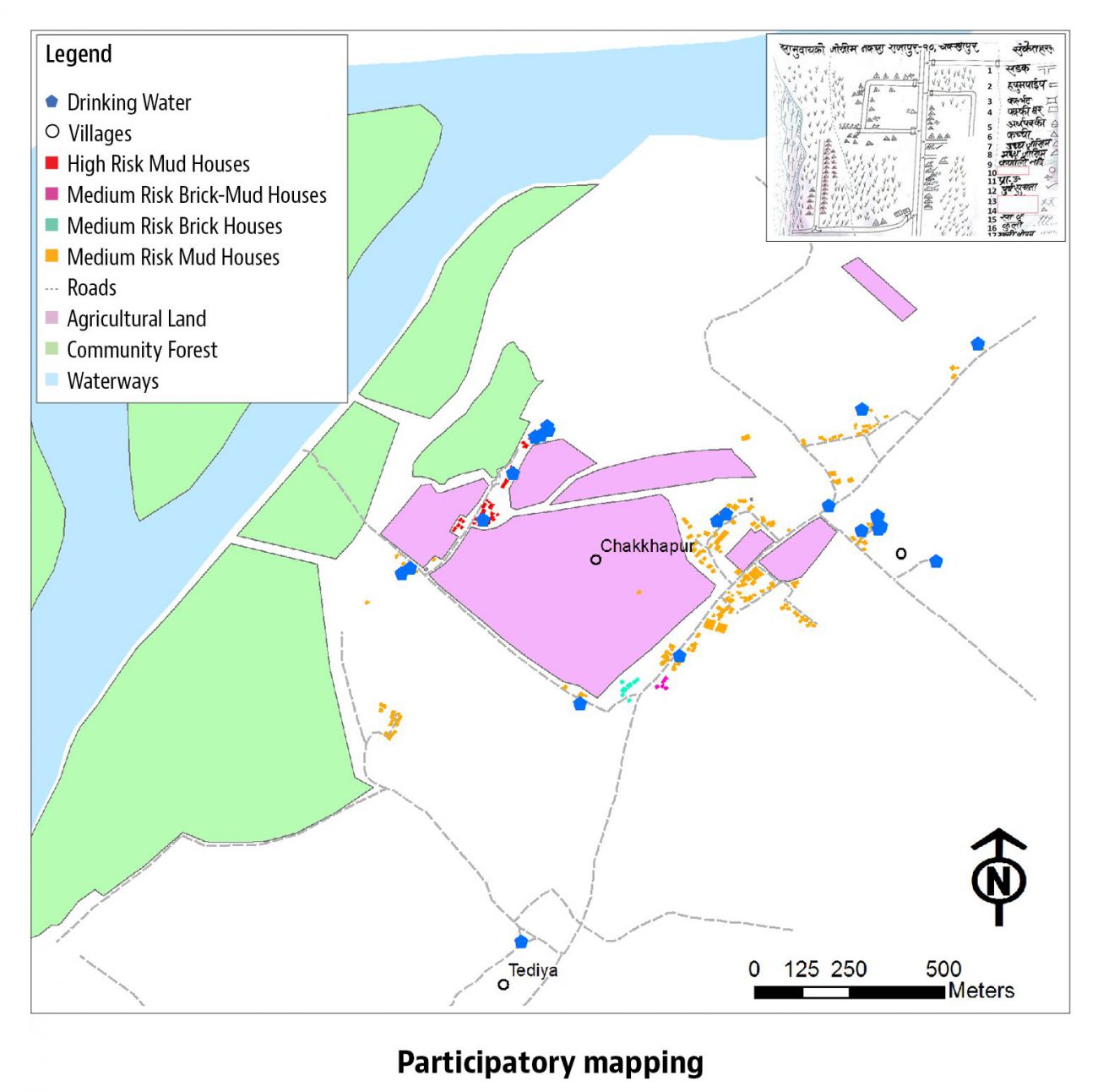
For this work, researchers from the IIASA Risk and Resilience and Ecosystems Services and Management Programs developed an approach that combines community-based participatory mapping processes with emerging internet-based digital mapping techniques [2]. In collaboration with Practical Action (a UK non-profit organization) and local professionals, IIASA researchers demonstrated the value and potential of this participatory and collaborative digital mapping approach in the flood-prone lower Karnali River basin in western Nepal.
The new digital community maps are richer in content, more accurate, and easier to update and share than those produced using conventional vulnerability and capacity assessments. The process engaged a wide range of stakeholders to generate geographic information on resources, capacities and flood risks of pilot communities based on their local needs. This approach, as an inclusive form of risk knowledge generation, can make important contribution to the understanding of disaster risk and therefore help enhance disaster resilience. The team continues to work with collaborators to map more communities in western Nepal and mountainous Peru [3].
Conventional hand-drawn community risk map, capacity map, and social map versus digital community map produced via a participatory and collaborative mapping approach.
References
[1] UN Office for Disaster Risk Reduction (2015). Sendai Framework for Disaster Risk Reduction 2015-2030. Geneva.
[2] McCallum I, Liu W, See L, Mechler R, Keating A, Hochrainer-Stigler S, Mochizuki J, Fritz S, et al. (2016). Technologies to Support Community Flood Disaster Risk Reduction. International Journal of Disaster Risk Science 7 (2): 198-204.
[3] Liu W, Dugar S, McCallum I, Thapa G, See L, Budhathoki N, Mechler R, Brown S et al. Participatory and Collaborative Digital Mapping to Enhance Disaster Resilience. Environmental Science and Policy, in review.
Collaborators
- Practical Action and Practical Action Consulting, UK and Nepal.
- International Federation of Red Cross and Red Crescent Societies
- Kathmandu Living Labs, Nepal

