Wildfires of the future
Wildfires have devastating effects across the globe, and as countries struggle to deal with their increased frequency under climate change, predicting their future impacts is crucial. To do this, researchers from the Tropical Futures Initiative adapted the IIASA wildfire model to Indonesia, adding the effect of burning peat and incorporating crowdsourced data on human activity.
Wildfires not only damage property and cause substantial air pollution, they also endanger lives and livelihoods. In Indonesia, fires affect millions of hectares of land, producing severe smoke haze pollution, and leading to CO2 emissions comparable to the annual fossil fuel emissions of India.
Assessing the area of land burned is an important step in estimating the cost of wildfires to society, their effect on air quality, and the CO2 emissions they might cause. The IIASA wildfire climate impacts and adaptation model (FLAM) has been developed to project future burned areas and to assess climate change impacts and adaptation options.
To do this, the model combines key information on climate, human activity, and fuel moisture and availability.
FLAM has previously been used to explore wildfires in Europe, and has performed well when compared with real historical data [1][2]. In the latest study, along with adapting the model for Indonesia, the researchers upgraded the model in several ways [3].
First, they included the impacts of burning peat as well as forests. Peatlands act as globally important carbon storage, and including them is crucial to understanding the true impacts of wildfires.
Second, the team developed a new approach for determining the probability that a fire would start .
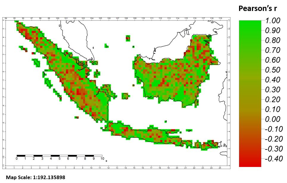
Finally, the team improved the model’s representation of human activity—which substantially increases the chances of wildfires—by using maps developed at IIASA based on data generated by citizen scientists searching satellite images for signs of human activity. When tested against real data collected in 2000-2008, the model showed satisfactory accuracy.
Spatial correlation between the FLAM model projections of yearly burned areas for the forest fires and real-world data for the period 2000-2008.
References
[1] Krasovskii A, Khabarov N, Migliavacca M, Kraxner F, & Obersteiner M (2016). Regional aspects of modelling burned areas in Europe. International Journal of Wildland Fire 25 (8): 811-818.
[2] Khabarov N, Krasovskii AA, Obersteiner M, Swart R, Dosio A, San-Miguel-Ayanz J, Durrant T, Camia A, et al. (2016). Forest fires and adaptation options in Europe. Regional Environmental Change 16 (1): 21-30.
[3] Krasovskii A, Khabarov N, Kraxner F, Schepaschenko D, Pietsch S, Cantele M, Pirker J, Yowargana P, et al. (2017) Modeling wildfires in Indonesia with the FLAM model, Environmental Research Letters (submitted).
Further information
The project Delivering Incentives to End Deforestation: Global Ambition, Private/Public Finance, and Zero-Deforestation Supply Chains is funded by the Norwegian Agency for Development Cooperation under agreement number QZA-0464 QZA-16/0218;
Research Program Future Forests, funded by the Swedish Foundation for Strategic Environmental Research.

